K6CCC
Well-known member
- First Name
- Jim
- Joined
- Sep 12, 2024
- Threads
- 26
- Messages
- 762
- Reaction score
- 737
- Location
- Glendora, Calif.
- Vehicles
- 2024 Lightning Flash ER in Antimatter Blue w/9.6 PPO , 2017 Corolla (wife's car)
- Occupation
- Retired from 2-Way radio systems
- Thread starter
- #1
I took a little drive on Sunday mostly in the southern California desert. 603.6 miles in 17 hours 34 minutes. It was a fun day, but quite long. Charged 4 times on the trip. I'm going to tell you about it. Warning, this is gonna get a bit long...
If you don't care what the trip was for, you can skip this paragraph. One of my hobbies is GeoCaching. For those that don't know, GeoCaching is a sport where people place a container somewhere and use a web based system to publish the location. Then other people use a GPS to go find it, then log the find on the online system. The person who places a cache is responsible to maintain that cache should that become needed. One of the caches that I placed is at Ibex Pass (about 40 miles north of Baker). It's 202 miles from my house so I normally perform any routine maintenance when I'm in that area for a race I help support every year. I knew that my Ibex Pass cache badly needed some repair, and I was going to repair it when I was going to out there for the race a month ago, but got sick and did not help with the race. So a special trip out was required. But if I'm going to spend a good part of the day and over 400 miles of driving, I'm going to make the trip worthwhile. So a longer drive was planned so I could log a bunch of other caches and a certain type of cache called an Adventure Lab. Now on to the trip...
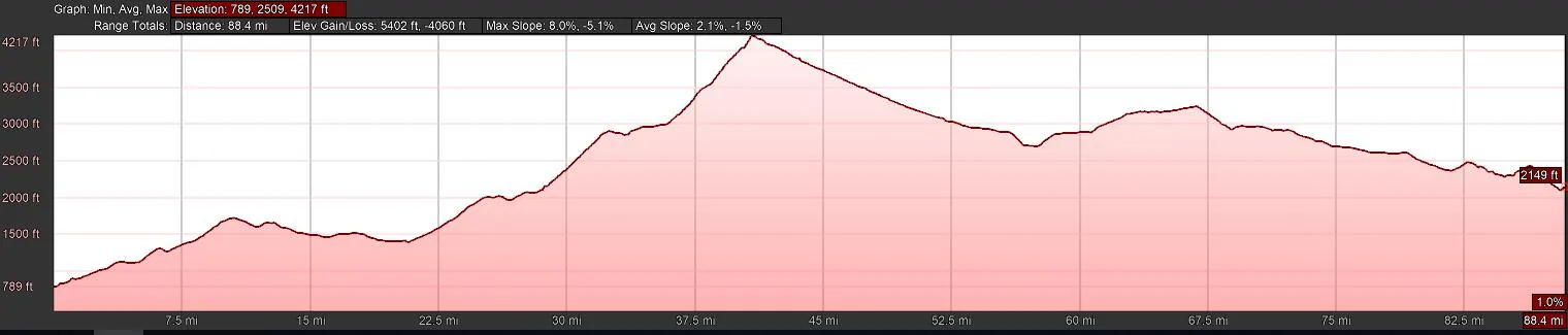
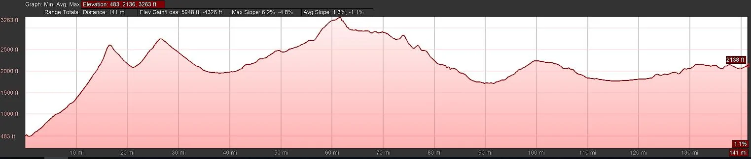
I will intersperse locations with latitude and longitude that you plug into Goggle Earth if you want to see where they are. I also added elevation as that does play into the story. All times listed are in 24 hour format. Also if this works right, I have inserted route and elevation charts from Google Earth for each segment. Note the distance shown on the route images are based on Google Earth, and my differ from my odometer numbers. Some of that is due to detours for GeoCaches not shown on the route.
Near home 34° 06' 49.91"N 117° 50' 47.15"W Ele. 793'
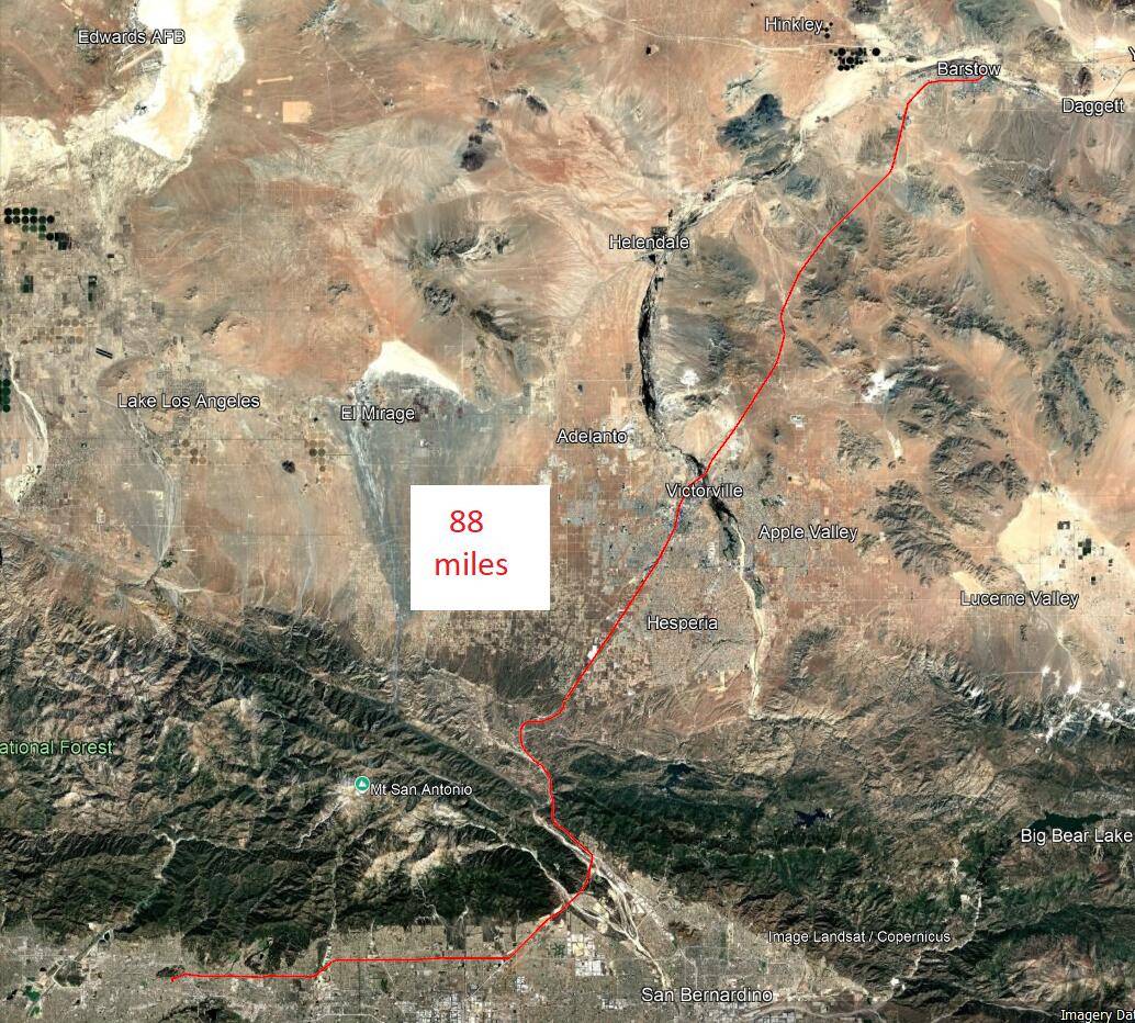
Left home at 0644 with 100% charge from my FCSP. Headed east on I-210, then north on I-15 over Cajon pass and onto the fairly new 120 stall Tesla SuperCharger in Barstow with some GeoCaching in Hesperia along the way. Got to admit that seeing 120 charging stalls is impressive. These are the new V4 SuperChargers so they have the longer cables which is nice for our trucks. To get there, you have to drive over Cajon pass which has a pretty good climb and then a few smaller hills to get over before getting to Barstow. Parked in the Barstow SuperCharger next to another Lightning and chatted with the owner for a couple minutes before walking across the street to a Del Taco for breakfast. I was only down to 64% when I got to Barstow so it did not take all that long to charge. Just as we were leaving breakfast, I was notified that the charge ended at 90%, so hustled across the street to unplug to avoid any idle fee.
I-15 Cajon Summit 34° 21' 09.08"N 117° 26' 18.13"W Ele. 4211'
Barstow Tesla SC 34° 53' 37.93"N 117° 00' 10.13"W Ele. 2134'
Home to Barstow 102 miles - start 100% @ 0644, arrive 64% @ 0907
Home to Barstow:


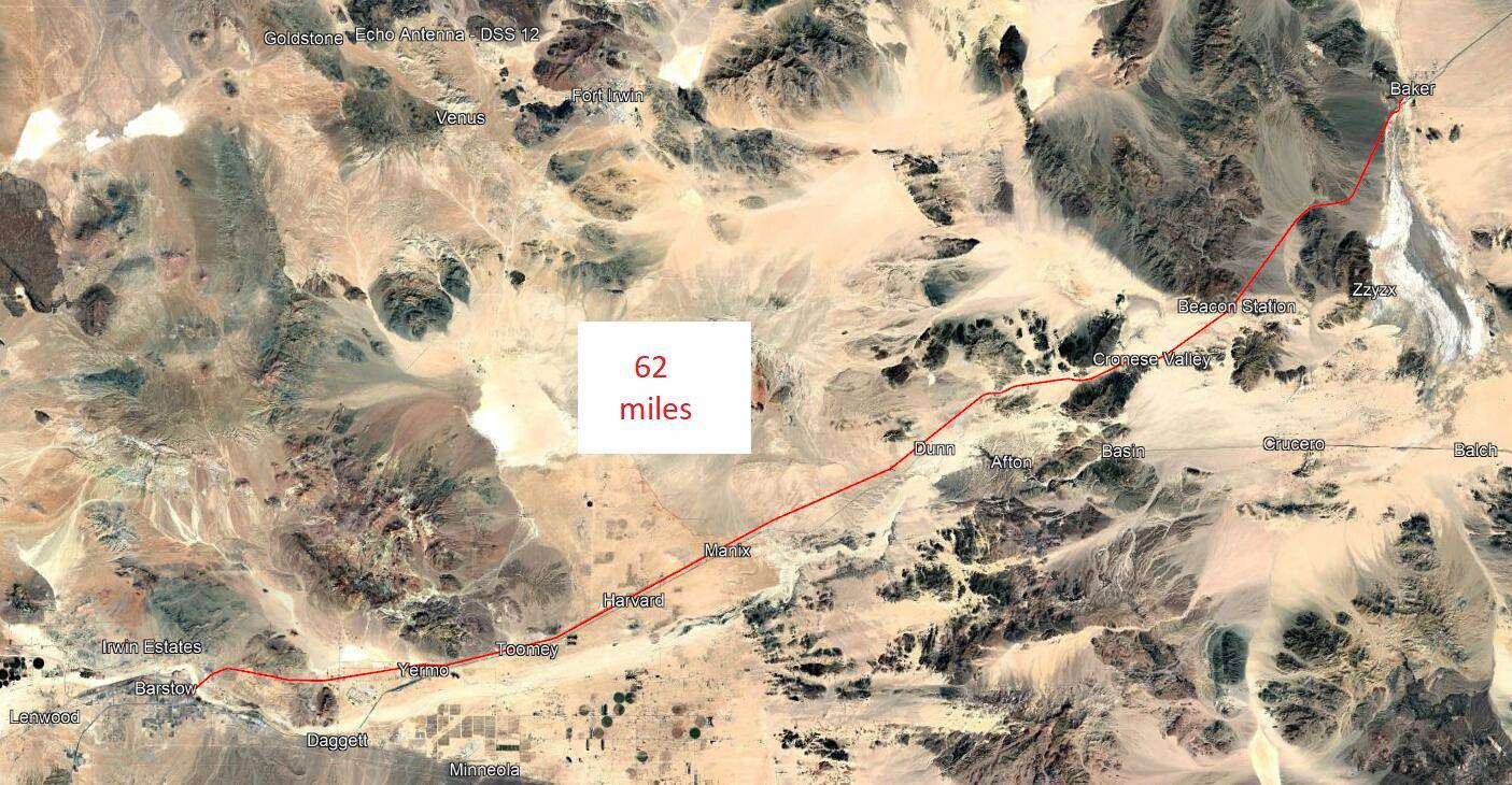
Left Barstow at 0936 and headed north east on I-15. Spotted the 40 stall Tesla SC in Yermo, but did not need it. Continued to Baker where I found the Tesla SuperCharger (not available to our trucks), and right next door the Electrify America charger that I expected to use in a couple hours. Then north on Highway 127 for about 40 miles to Ibex pass where I was able to do the maintenance on my GeoCache. Then back to Baker to the E.A. charging station. There are 12 stalls, and one was out of service, but there were two open. This was the first time I have ever charged at an E.A. station, and I had purchased an E.A. subscription the night before and will cancel that before it renews. So I had to figure out how to use the station with the E.A. app, but that was not hard. While charging we walked over to find a couple of nearby GeoCaches before waiting in the truck for the last couple minutes when charge stopped at 90%. Worked out well for me. During the time we were there, there was always one or two stalls open except right at the end when the station was full and one car waiting.
Ibex Pass GeoCache 35° 47' 35.66"N 116° 20' 07.97"W Ele. 1222'
Baker Elec. Amer. 35° 15' 43.79"N 116° 04' 52.48"W Ele. 933'
Barstow to Baker via Ibex Pass 145 miles - start 90% @ 0936, arrive 34% @ 1239
Barstow to Baker:


Baker to Ibex Pass:


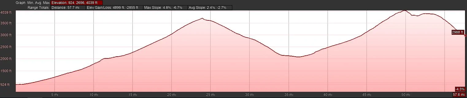
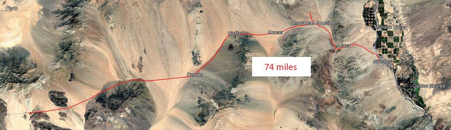
After charging in Baker we did a little more GeoCaching in Baker and got lunch. The next leg was south and east on Kelbaker Road. That is a 57 mile road that cuts through the Mojave National Preserve before arriving at I-40. It's largely the middle of nowhere. I have not driven that route in something close to 40 years and it was a dirt road back then. Much to my surprise, it's now paved the entire way. In the middle is Kelso which is only important to the railroad, but there is a visitor center (currently closed for remodel), but there is a GeoCache there so we stopped. However you climb out of Baker, then down to Kelso, and climb over more hills to get to I-40. Then east on I-40 to the point where old route 66 crosses I-40 at Fenner. The original plan was to head a few miles east on old Route 66 to Goffs for some more GeoCaches and then back to Fenner to charge at the Electrify America station, but in my bad timing, E.A. took the station out of service for upgrade two days before my trip. I knew about that in advance so it was not a surprise. Instead we went on into Needles which has two Tesla SuperChargers and an Electrify America station. In an unexpected twist, a little east of Goffs we came across a lady and her grandmother with a flat time. She did not have any sort of roadside assistance available. We spent a while attempting to help her, but her factory lug wrench did not fit her aftermarket lug nuts, so we could not change the tire for her. I was very uncomfortable leaving a lady in the middle of the desert with a disabled car so we ended up calling 911. California Highway Patrol responded and presumably they were able to get her some help. Then on to Needles for some more GeoCaches. At the last Adventure Lab stop I was about to look to see exactly where the SuperChargers were. However before I got the Tesla app loaded, I saw one of the Supercharger stations in the parking lot right in front of me. How handy. There are 12 stalls and only one Tesla MY charging. A Rivan arrived a few minutes later. The Tesla driver came over to chat and was very interested in my Lightning. You can see from the altitudes listed that there is climbing up and down involved.
Kelbaker Rd peak 1 35° 08' 46.00"N 115° 44' 00.35"W Ele. 3710'
Kelso 35° 00' 42.99"N 115° 39' 15.30"W Ele. 2129'
Kelbaker Rd peak 2 34° 48' 42.03"N 115° 36' 33.47"W Ele. 4045'
I-40 & Kelbaker Rd 34° 43' 15.29"N 115° 40' 42.74"W Ele. 2983'
Feener Elec. Amer. 34° 49' 01.12"N 115° 10' 58.27"W Ele. 2087'
Needles Tesla SC 34° 51' 02.53"N 114° 37' 22.51"W Ele. 510'
Baker to Needles 131 miles - start 90% @ 1323, arrive 38% @ 1946
Kelbaker Road:


Kelbaker Road to Needles:


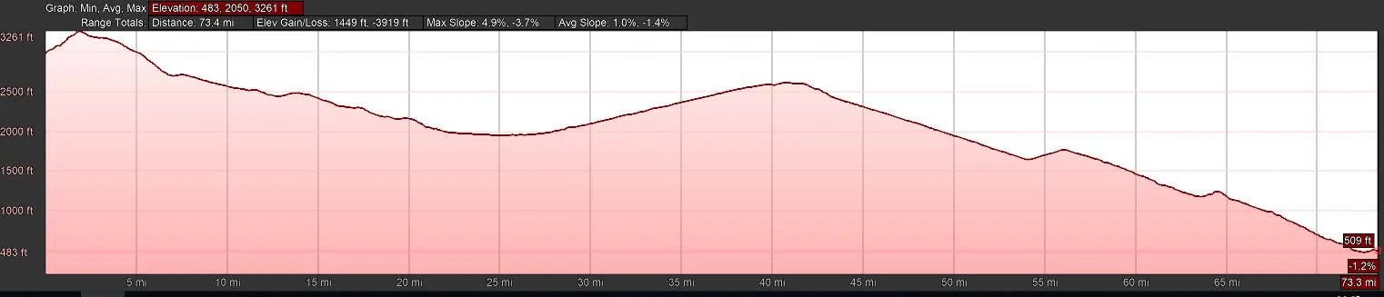
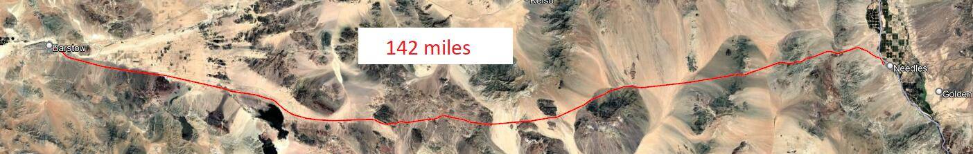
After charging in Needles and eating some dinner, I was sort of hoping not to need to make another charging stop, but not overly confident about that. In good conditions, and if I kept the speed down, I MIGHT have been able to make it, but that was not to be the case. Our route was I-40 west to Barstow and then south on I-15 to I-210 to home - 230 miles, and a bunch of hills to go over too. However it was getting late, so I generally had the cruise control at 76 mph and we had some pretty strong quartering headwinds. A few miles into the route, the truck said I would arrive at home at -1%. It went down from there as the headwinds beat it down. Ok, one more charge. As we continued west the effect of my speed and the winds became more obvious and I slowly watched the estimated charge for arrival at the Barstow SuperCharger drop the farther west that we went. I was very confident that I would make it, but I was doing the math regularly in my head, and determined that I did not need to slow down. Note that the route along I-40 from Needles to Barstow in addition to being a real desert is also a charging desert. There is absolutley no charging other than the previously mentioned EA station at Fenner that is getting upgraded at the moment. According to PlugShare, there is an EA station coming to Ludlow, but it's not built yet. Arrived at the Barstow Supercharger and pulled into the same stall that I used in the morning.
Needles to Barstow 138 miles - start 89% @ 2023, arrive 19% @ 2223
Needles to Barstow:


I had spent a lot of time sitting, so mostly just walked around while charging. My goal was to charge enough that I could make it the just under 100 miles home and then a round trip into work the next day. Although I could have charged at home, I would have had to play car shuffle after getting home and again in the morning because I have to be in the rear parking spot in my one lane driveway in order for my charging cable to reach the truck. Did not want to have to deal with that. And because of the winds, built in some reserve. So I charged till shortly after the charge rate slowed at 80%, and we headed off for the last leg.
Barstow to Home 90 miles - start 83% @ 2303, arrive 48% @ 0022
Charging summary (subscription with both Tesla and E.A.):
Barstow Tesla 64% - 90% (38 KWH) @ $0.43/KWH = $16.34 - Average rate 78.62 KW
Baker E.A. 34% - 90$ (73 KWH) @ $0.48/KWH = $35.04 - Average rate 99.55 KW
Needles Tesla 38% - 89% (71 KWH) @ $0.26/KWH = $18.46 - Average rate 118.33 KW
Barstow Tesla 19% - 83% (86 KWH) @ $0.43/KWH = $36.98 - Average rate 132.31 KW
Home FCSP 48% - 100% (68 KWH) @ $0.24/KWH = $16.35
Peak charging rate at all four DC chargers was 175 - 185 KWH.
Total 603.6 miles in 17:34 using 336 KWH at a cost of $123.17. Average was 1.79 miles / KWH which is well below my average (2.4 since I've owned the truck), but involved faster driving, lots of hills, and some brutal winds. Air conditioning was on almost the entire trip - my passenger kept his side at 60, Brrr.
Note the last line for home is calculated as I did not charge when I got home, but is needed to total the trip.
For the GeoCaching, I logged 35 GeoCaches and 31 Adventure Lab stops, so it was a good day.
If you don't care what the trip was for, you can skip this paragraph. One of my hobbies is GeoCaching. For those that don't know, GeoCaching is a sport where people place a container somewhere and use a web based system to publish the location. Then other people use a GPS to go find it, then log the find on the online system. The person who places a cache is responsible to maintain that cache should that become needed. One of the caches that I placed is at Ibex Pass (about 40 miles north of Baker). It's 202 miles from my house so I normally perform any routine maintenance when I'm in that area for a race I help support every year. I knew that my Ibex Pass cache badly needed some repair, and I was going to repair it when I was going to out there for the race a month ago, but got sick and did not help with the race. So a special trip out was required. But if I'm going to spend a good part of the day and over 400 miles of driving, I'm going to make the trip worthwhile. So a longer drive was planned so I could log a bunch of other caches and a certain type of cache called an Adventure Lab. Now on to the trip...
I will intersperse locations with latitude and longitude that you plug into Goggle Earth if you want to see where they are. I also added elevation as that does play into the story. All times listed are in 24 hour format. Also if this works right, I have inserted route and elevation charts from Google Earth for each segment. Note the distance shown on the route images are based on Google Earth, and my differ from my odometer numbers. Some of that is due to detours for GeoCaches not shown on the route.
Near home 34° 06' 49.91"N 117° 50' 47.15"W Ele. 793'
Left home at 0644 with 100% charge from my FCSP. Headed east on I-210, then north on I-15 over Cajon pass and onto the fairly new 120 stall Tesla SuperCharger in Barstow with some GeoCaching in Hesperia along the way. Got to admit that seeing 120 charging stalls is impressive. These are the new V4 SuperChargers so they have the longer cables which is nice for our trucks. To get there, you have to drive over Cajon pass which has a pretty good climb and then a few smaller hills to get over before getting to Barstow. Parked in the Barstow SuperCharger next to another Lightning and chatted with the owner for a couple minutes before walking across the street to a Del Taco for breakfast. I was only down to 64% when I got to Barstow so it did not take all that long to charge. Just as we were leaving breakfast, I was notified that the charge ended at 90%, so hustled across the street to unplug to avoid any idle fee.
I-15 Cajon Summit 34° 21' 09.08"N 117° 26' 18.13"W Ele. 4211'
Barstow Tesla SC 34° 53' 37.93"N 117° 00' 10.13"W Ele. 2134'
Home to Barstow 102 miles - start 100% @ 0644, arrive 64% @ 0907
Home to Barstow:
Left Barstow at 0936 and headed north east on I-15. Spotted the 40 stall Tesla SC in Yermo, but did not need it. Continued to Baker where I found the Tesla SuperCharger (not available to our trucks), and right next door the Electrify America charger that I expected to use in a couple hours. Then north on Highway 127 for about 40 miles to Ibex pass where I was able to do the maintenance on my GeoCache. Then back to Baker to the E.A. charging station. There are 12 stalls, and one was out of service, but there were two open. This was the first time I have ever charged at an E.A. station, and I had purchased an E.A. subscription the night before and will cancel that before it renews. So I had to figure out how to use the station with the E.A. app, but that was not hard. While charging we walked over to find a couple of nearby GeoCaches before waiting in the truck for the last couple minutes when charge stopped at 90%. Worked out well for me. During the time we were there, there was always one or two stalls open except right at the end when the station was full and one car waiting.
Ibex Pass GeoCache 35° 47' 35.66"N 116° 20' 07.97"W Ele. 1222'
Baker Elec. Amer. 35° 15' 43.79"N 116° 04' 52.48"W Ele. 933'
Barstow to Baker via Ibex Pass 145 miles - start 90% @ 0936, arrive 34% @ 1239
Barstow to Baker:
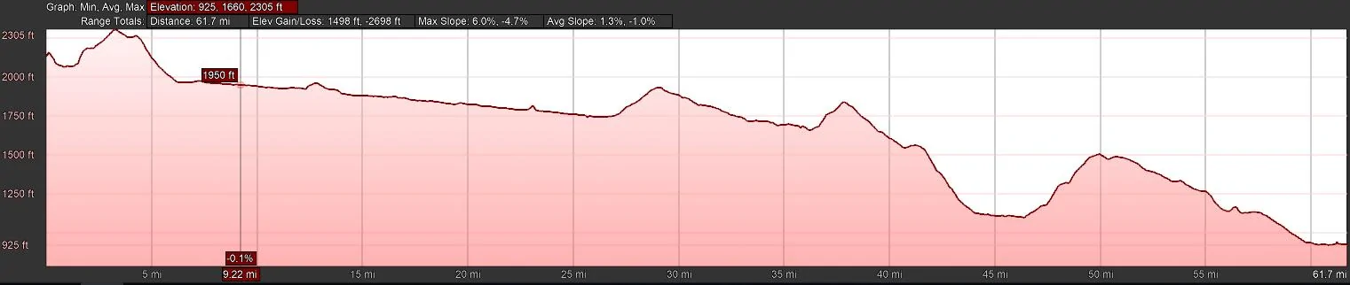
Baker to Ibex Pass:
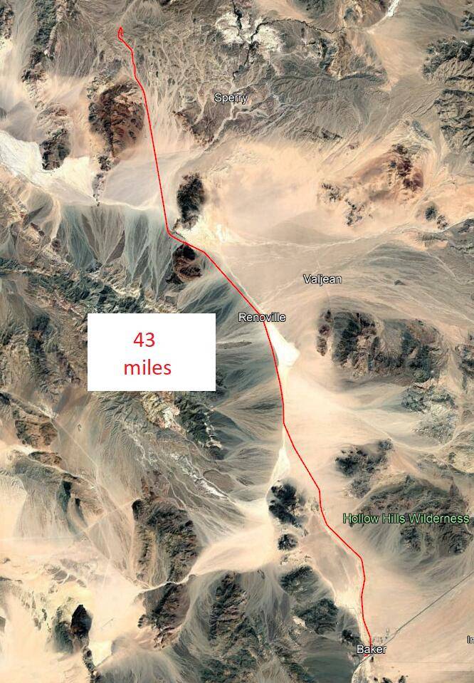
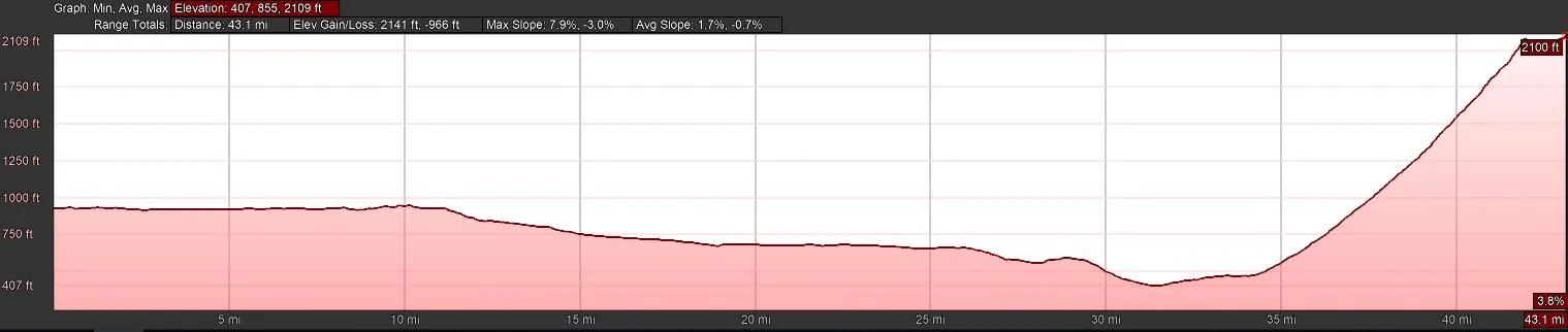
After charging in Baker we did a little more GeoCaching in Baker and got lunch. The next leg was south and east on Kelbaker Road. That is a 57 mile road that cuts through the Mojave National Preserve before arriving at I-40. It's largely the middle of nowhere. I have not driven that route in something close to 40 years and it was a dirt road back then. Much to my surprise, it's now paved the entire way. In the middle is Kelso which is only important to the railroad, but there is a visitor center (currently closed for remodel), but there is a GeoCache there so we stopped. However you climb out of Baker, then down to Kelso, and climb over more hills to get to I-40. Then east on I-40 to the point where old route 66 crosses I-40 at Fenner. The original plan was to head a few miles east on old Route 66 to Goffs for some more GeoCaches and then back to Fenner to charge at the Electrify America station, but in my bad timing, E.A. took the station out of service for upgrade two days before my trip. I knew about that in advance so it was not a surprise. Instead we went on into Needles which has two Tesla SuperChargers and an Electrify America station. In an unexpected twist, a little east of Goffs we came across a lady and her grandmother with a flat time. She did not have any sort of roadside assistance available. We spent a while attempting to help her, but her factory lug wrench did not fit her aftermarket lug nuts, so we could not change the tire for her. I was very uncomfortable leaving a lady in the middle of the desert with a disabled car so we ended up calling 911. California Highway Patrol responded and presumably they were able to get her some help. Then on to Needles for some more GeoCaches. At the last Adventure Lab stop I was about to look to see exactly where the SuperChargers were. However before I got the Tesla app loaded, I saw one of the Supercharger stations in the parking lot right in front of me. How handy. There are 12 stalls and only one Tesla MY charging. A Rivan arrived a few minutes later. The Tesla driver came over to chat and was very interested in my Lightning. You can see from the altitudes listed that there is climbing up and down involved.
Kelbaker Rd peak 1 35° 08' 46.00"N 115° 44' 00.35"W Ele. 3710'
Kelso 35° 00' 42.99"N 115° 39' 15.30"W Ele. 2129'
Kelbaker Rd peak 2 34° 48' 42.03"N 115° 36' 33.47"W Ele. 4045'
I-40 & Kelbaker Rd 34° 43' 15.29"N 115° 40' 42.74"W Ele. 2983'
Feener Elec. Amer. 34° 49' 01.12"N 115° 10' 58.27"W Ele. 2087'
Needles Tesla SC 34° 51' 02.53"N 114° 37' 22.51"W Ele. 510'
Baker to Needles 131 miles - start 90% @ 1323, arrive 38% @ 1946
Kelbaker Road:
Kelbaker Road to Needles:
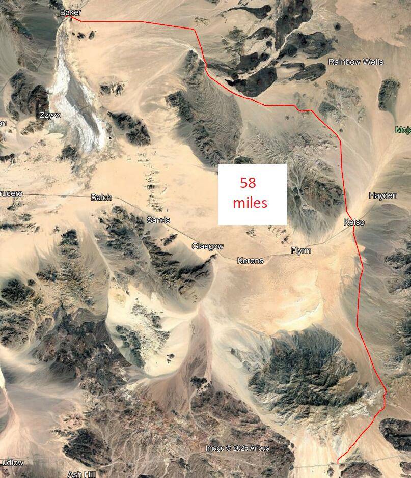
After charging in Needles and eating some dinner, I was sort of hoping not to need to make another charging stop, but not overly confident about that. In good conditions, and if I kept the speed down, I MIGHT have been able to make it, but that was not to be the case. Our route was I-40 west to Barstow and then south on I-15 to I-210 to home - 230 miles, and a bunch of hills to go over too. However it was getting late, so I generally had the cruise control at 76 mph and we had some pretty strong quartering headwinds. A few miles into the route, the truck said I would arrive at home at -1%. It went down from there as the headwinds beat it down. Ok, one more charge. As we continued west the effect of my speed and the winds became more obvious and I slowly watched the estimated charge for arrival at the Barstow SuperCharger drop the farther west that we went. I was very confident that I would make it, but I was doing the math regularly in my head, and determined that I did not need to slow down. Note that the route along I-40 from Needles to Barstow in addition to being a real desert is also a charging desert. There is absolutley no charging other than the previously mentioned EA station at Fenner that is getting upgraded at the moment. According to PlugShare, there is an EA station coming to Ludlow, but it's not built yet. Arrived at the Barstow Supercharger and pulled into the same stall that I used in the morning.
Needles to Barstow 138 miles - start 89% @ 2023, arrive 19% @ 2223
Needles to Barstow:
I had spent a lot of time sitting, so mostly just walked around while charging. My goal was to charge enough that I could make it the just under 100 miles home and then a round trip into work the next day. Although I could have charged at home, I would have had to play car shuffle after getting home and again in the morning because I have to be in the rear parking spot in my one lane driveway in order for my charging cable to reach the truck. Did not want to have to deal with that. And because of the winds, built in some reserve. So I charged till shortly after the charge rate slowed at 80%, and we headed off for the last leg.
Barstow to Home 90 miles - start 83% @ 2303, arrive 48% @ 0022
Charging summary (subscription with both Tesla and E.A.):
Barstow Tesla 64% - 90% (38 KWH) @ $0.43/KWH = $16.34 - Average rate 78.62 KW
Baker E.A. 34% - 90$ (73 KWH) @ $0.48/KWH = $35.04 - Average rate 99.55 KW
Needles Tesla 38% - 89% (71 KWH) @ $0.26/KWH = $18.46 - Average rate 118.33 KW
Barstow Tesla 19% - 83% (86 KWH) @ $0.43/KWH = $36.98 - Average rate 132.31 KW
Home FCSP 48% - 100% (68 KWH) @ $0.24/KWH = $16.35
Peak charging rate at all four DC chargers was 175 - 185 KWH.
Total 603.6 miles in 17:34 using 336 KWH at a cost of $123.17. Average was 1.79 miles / KWH which is well below my average (2.4 since I've owned the truck), but involved faster driving, lots of hills, and some brutal winds. Air conditioning was on almost the entire trip - my passenger kept his side at 60, Brrr.
Note the last line for home is calculated as I did not charge when I got home, but is needed to total the trip.
For the GeoCaching, I logged 35 GeoCaches and 31 Adventure Lab stops, so it was a good day.
Sponsored
Last edited: